
Importance of Small Wetlands
Abstract
Coastal tidal marshes are an important ecosystem in the Carolinas as they provide many essential resources and services to our coastal communities. The imminence of rising sea levels threatens to submerge marshes, which could negatively impact agriculture, drinking water, inland communities, and coastal ecosystems.
As climate changes, it will become critical to provide protected corridors through which coastal tidal marshes can migrate inland and continue to protect our coastlines. In the Carolinas, the creation of these corridors may require the aid of humans to remove man-made barriers (e.g., hardened shorelines), conserve and manage uplands, and collaborate with coastal communities and farmers to provide mutual social, economic, and environmental benefits for all.
Problem Statement
As our climate continues to warm over the coming decades, our sea levels will also rise. Many of our saltwater marshes are located on the Carolina coast, barely above current sea level. In fact, 1,729 square miles of the North Carolina coast is less than one meter above sea level (N.C. Interagency Leadership Team, 2010). As sea levels rise, these important wetlands will be vulnerable to inundation and transformation from coastal tidal marsh to open water. Human interventions, such as shorelines hardened with seawalls or bulkheads, berms, dikes, roads and even buildings could further prevent coastal tidal marshes from inland migration (Fuller, 2011). The loss of these wetlands will have negative impacts on coastal communities who rely on these wetlands as a buffer against wave action, flooding, and saltwater intrusion which can impact agriculture and harm infrastructure. It will also negatively affect the many types of flora and fauna that depend on these marshes for critical habitat.
The United States Environmental Protection Agency (EPA) defines wetlands as “areas where water covers the soil or is present either at or near the surface of the soil all year or for varying periods during the year, including during the growing season.”8 They are often identified by their hydric soils, hydrophytic vegetation, and seasonally or permanently saturated soil within one foot below the ground surface. Depending on the wetland type, the hydrology of small wetlands ranges from standing water for much of the year to saturated soil just below the surface for a few weeks. Small wetlands occur across North Carolina ecoregions in varying landscape positions and proportions (Figure 1).
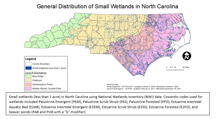
Figure 1. General Distribution of Small Wetlands in North Carolina (9,11)
Abstract
Wetlands occur throughout North Carolina in variable sizes and landscape positions. How wetlands are protected and regulated changes over time based on the definition of a jurisdictional wetland. Impacts to federal and state jurisdictional wetlands resulting in loss are regulated by the United States Army Corps of Engineers (USACE) and North Carolina Department of Environmental Quality (NCDEQ), respectively. Depending on the type of impact activities and permitting thresholds, impacts to jurisdictional wetlands may require a permit. Currently, wetlands that are not adjacent to or lack a hydrologic surface connection with a relatively permanent water, often referred to as geographically isolated wetlands, are not considered federally jurisdictional. In North Carolina, isolated wetlands have higher state permitting thresholds than federal jurisdictional wetlands. When a permit is required, impacts to wetlands must be avoided and minimized, as practicable. Because wetland regulations are focused on hydrologic connectivity and the size (or amount) of impacts, some small wetlands may be lost without requiring permitting and avoidance and minimization measures if total impacts for a proposed project are under the permitting threshold. Because the size of a wetland is not a direct indicator of how well the ecosystem is functioning or the value it has to the surrounding environment, other criteria based on the benefits a wetland can provide need to be incorporated into wetland regulations [1]. Small wetlands provide benefits such as flood storage, water quality improvement, recreational opportunities, economic growth, public health, and increased biodiversity, and therefore should be protected. A landscape approach to regulate wetlands can be used to avoid and minimize impacts to wetlands that have the potential to provide the most environmental, economic, and community benefits.
Problem Statement: Loss of Small Wetlands
Due to development and other human activities that have resulted in land-use changes, a substantial amount of wetlands have been lost in the United States. The United States Department of Agriculture (USDA) Natural Resources Conservation Service (NRCS) estimates that approximately 220 million acres of wetlands once existed in the lower 48 states.[2] By 1984, it is estimated that 54% of those wetlands were drained or filled; most wetlands were drained for crop production. [3,4]
In North Carolina, approximately half of all wetlands were lost by the mid-1980s, with the amount of wetlands reduced from approximately 11 million acres to around 4 million acres.[5] For example, mountain bogs, a rare wetland type endemic to western North Carolina, have been estimated to cover over 5,000 acres in the past, but now only cover approximately 500 acres.[6] Pocosins, a wetland type that occurs in eastern North Carolina also known as swamp-on-a-hill, once covered approximately 2.47 million acres; it has been estimated 33% of these wetlands have been destroyed.[4] Many Carolina bays, a unique basin wetland habitat also found in eastern North Carolina, have been lost due to draining and converting land for agriculture and other uses.[7] Because small wetlands are underrepresented in wetland inventories and mapping resources, the actual loss is difficult to assess.[5] For this report, small wetlands are defined as being less than an acre in size.
Small wetlands are a vital environmental resource that provide a wide variety of benefits to humans and should be protected; however, the level of protection provided by federal and state regulations varies based on the size, location, and surface water connection of a wetland. The importance of small wetlands is often misunderstood and therefore overlooked when establishing permitting thresholds. Small wetlands are often viewed as less valuable than larger wetlands based on false assumptions that small wetlands have shorter hydroperiods, support fewer species, and the species found in small wetlands also inhabit larger wetlands.[1] The destruction of small wetlands can lead to issues such as decreased water quality, increased flooding, a decline in biodiversity, and economic losses.[3] As discussed in this paper, the value of small wetlands needs to be better understood to promote their protection.
Background: Small Wetlands in North Carolina
The United States Environmental Protection Agency (EPA) defines wetlands as “areas where water covers the soil or is present either at or near the surface of the soil all year or for varying periods during the year, including during the growing season.”8 They are often identified by their hydric soils, hydrophytic vegetation, and seasonally or permanently saturated soil within one foot below the ground surface. Depending on the wetland type, the hydrology of small wetlands ranges from standing water for much of the year to saturated soil just below the surface for a few weeks. Small wetlands occur across North Carolina ecoregions in varying landscape positions and proportions (Figure 1).
Figure 1. General Distribution of Small Wetlands in North Carolina (9,11)
The United States Environmental Protection Agency (EPA) defines wetlands as “areas where water covers the soil or is present either at or near the surface of the soil all year or for varying periods during the year, including during the growing season.”[8] They are often identified by their hydric soils, hydrophytic vegetation, and seasonally or permanently saturated soil within one foot below the ground surface. Depending on the wetland type, the hydrology of small wetlands ranges from standing water for much of the year to saturated soil just below the surface for a few weeks. Small wetlands occur across North Carolina ecoregions in varying landscape positions and proportions (Figure 1).
The United States Environmental Protection Agency (EPA) defines wetlands as “areas where water covers the soil or is present either at or near the surface of the soil all year or for varying periods during the year, including during the growing season.”8 They are often identified by their hydric soils, hydrophytic vegetation, and seasonally or permanently saturated soil within one foot below the ground surface. Depending on the wetland type, the hydrology of small wetlands ranges from standing water for much of the year to saturated soil just below the surface for a few weeks. Small wetlands occur across North Carolina ecoregions in varying landscape positions and proportions (Figure 1).
Figure 1. General Distribution of Small Wetlands in North Carolina (9,11)
Figure 1. General Distribution of Small Wetlands in North Carolina (9,11)
The state of North Carolina is typically described using three physiographic provinces: Mountains, Piedmont, and Coastal Plain. These provinces are divided using Level III ecoregions boundaries (Figure 1).[9] Ecoregions are areas with distinctive ecological and geographical characteristics including landscape, land surface form, geology, soils, climate, and natural plant communities.[10] In North Carolina, the Blue Ridge ecoregion contains the Mountains province and is the farthest inland ecoregion of the state. The Piedmont ecoregion contains the Piedmont province and is located between the Blue Ridge escarpment bordering the Mountains and the fall line bordering the Southeastern Plains ecoregion. The Coastal Plain province consists of the Southeastern Plains and Middle Atlantic Coastal Plain ecoregions.
The National Wetlands Inventory (NWI) is a digitized map that provides general information about potential wetland areas, but it is not a reliable source for identifying all small wetlands. The NWI was created using aerial imagery primarily from the 1980s and involved a minimum mapping size of 0.5 acre, meaning wetlands smaller than 0.5 acre were often not included in the NWI.5 Wetlands that could not be detected using aerial photography were also not included in the NWI. Recent studies from the North Carolina Division of Water Resources (DWR) have shown that the NWI excludes many small wetlands, particularly in the Mountains and western Piedmont.[5] Because the NWI “is the only widely available map of wetland locations and extent within [North Carolina],” it is often used for natural resources management and project planning; however, the NWI was not intended to be used for such purposes.5 Accurate representation of small wetlands in readily available mapping resources would allow for the selection of projects and site locations that avoid and minimize impacts to small wetlands earlier in the project planning process.
Although there is not an accurate, comprehensive map of all wetlands across North Carolina, there are some known facts about the distribution and size of wetlands. The Mountains province has the least amount of wetlands compared to the other provinces of North Carolina (Figure 1). These wetlands are often small and occur in flat areas where surface water collects and groundwater discharges (Figure 2).12 The Piedmont contains more wetlands than the Mountains, but most wetlands are also typically small.5 Most of the wetlands in North Carolina are located in the Coastal Plain and tend to be larger than wetlands in the Mountains and Piedmont provinces.5
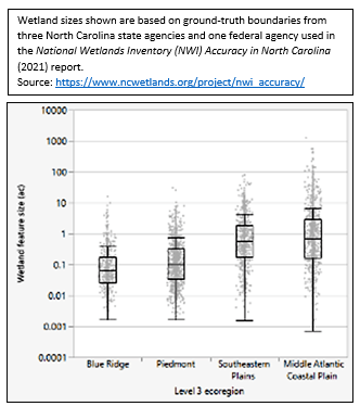
Figure 2. North Carolina Wetland Size Distribution by Ecoregion (13)
Although there is not an accurate, comprehensive map of all wetlands across North Carolina, there are some known facts about the distribution and size of wetlands. The Mountains province has the least amount of wetlands compared to the other provinces of North Carolina (Figure 1). These wetlands are often small and occur in flat areas where surface water collects and groundwater discharges (Figure 2).[12] The Piedmont contains more wetlands than the Mountains, but most wetlands are also typically small.[5] Most of the wetlands in North Carolina are located in the Coastal Plain and tend to be larger than wetlands in the Mountains and Piedmont provinces.5
Figure 2. North Carolina Wetland Size Distribution by Ecoregion (13)
North Carolina hosts a variety of wetlands that can be categorized into general wetland types using the NC Wetland Assessment Method (NCWAM) based on where they occur on the landscape and the functions they perform.[14] All wetland types can vary in size; however, seven NCWAM wetland types are common types for small wetlands (Table 1). Each wetland type provides multiple ecosystem services that benefit humans and the environment, with recreation, wildlife habitat, groundwater recharge, and water quality filtration common to all small wetland types.
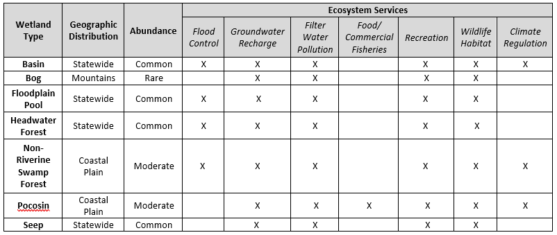
Table 1. Common NCWAM wetland types for small wetlands in North Carolina.
Flood Storage Benefits
An increase in the intensity and frequency of storms and heavy downpour events in recent years has led to more flooding in North Carolina.[15] Property damage in North Carolina related to hurricanes was estimated at $500,000 from 1970 to 1980 (equivalent to approximately $3.5 million today due to inflation) compared to $367 million from 2010 to 2020.[16,17] According to the 2020 North Carolina Climate Science Report, it is “very likely that extreme precipitation frequency and intensity” will continue to increase over the next century and “likely that increases in extreme precipitation will lead to increases in inland flooding.”[18] Because of wetland loss and degradation, flood damages from extreme precipitation events tend to be higher and more costly than if more properly functioning wetlands existed in various positions across the landscape.
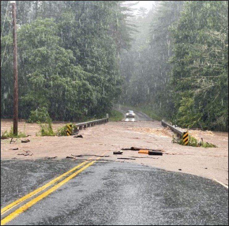
Photo: NC Department of Transportation. 2021 (21).
Background
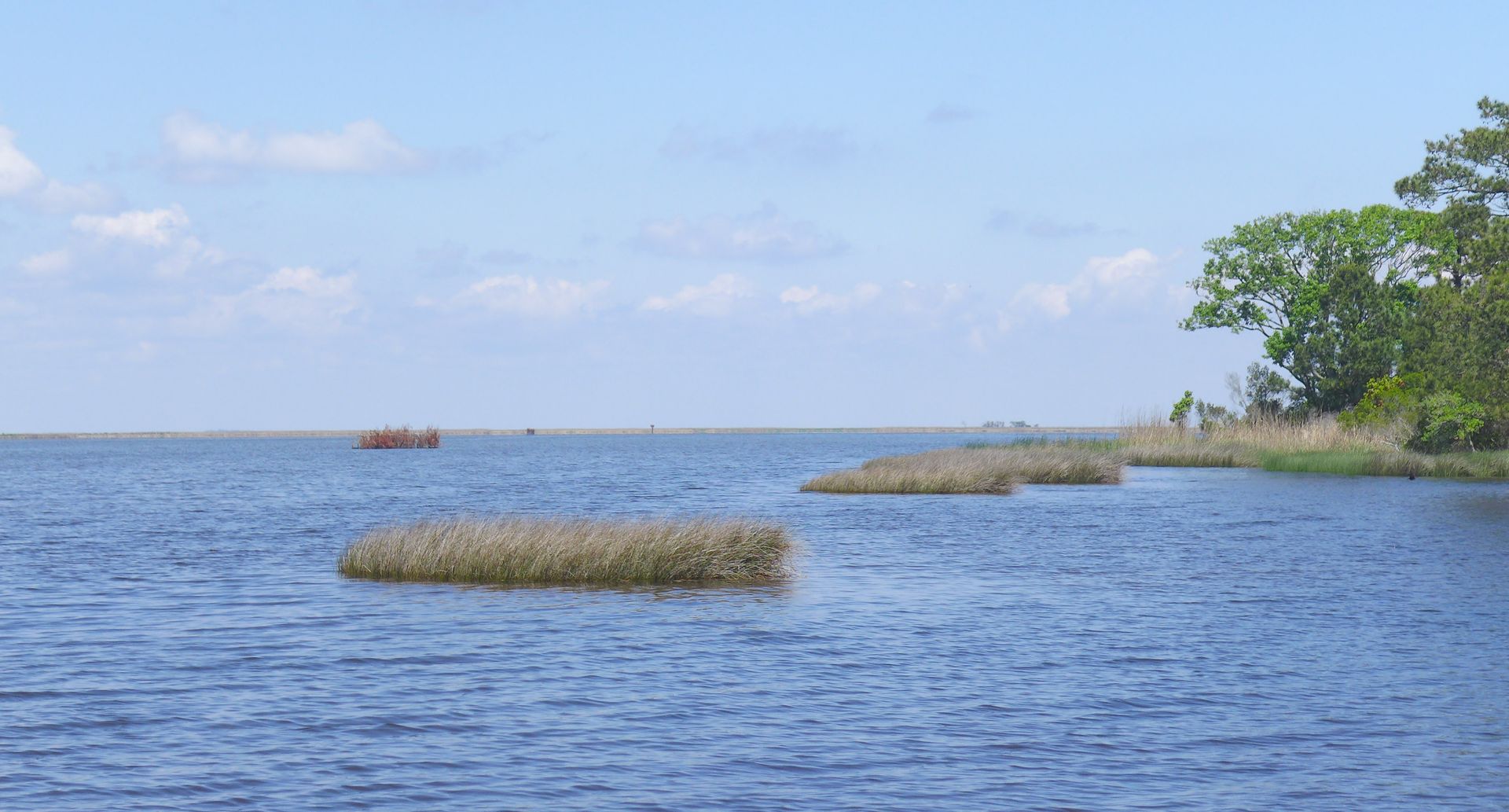
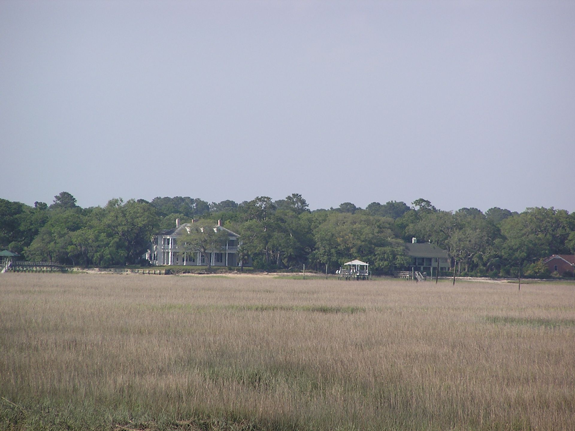
Coastal tidal marshes are non-forested wetlands occupied mostly by grasses and rushes (National Geographic, n.d.). They occur in both fresh and saltwater tidal areas. Coastal tidal marshes extend along hundreds of miles of coastline in the Carolinas (Nagy, 2015).
Coastal tidal marshes provide abundant services to humans and the environment. They help protect the shoreline from wave action and flood-causing storm surges. They help prevent saltwater intrusion, which in turn protects agricultural lands, drinking water supplies, and coastal communities. They also filter out terrestrial pollutants and lessen human impact on our oceans. Additionally, they provide habitat for many fish, birds, and other animals. (National Geographic, n.d.)
Coastal tidal marshes are abundant in the Carolinas but are threatened by human hydrologic management through ditching and channelization and activities that limit sediment flow to marshes such as upstream damming. They are also threatened by shoreline development that promotes the installation of bulkheads, seawalls, berms, and roads (Beever et al., 2012). Another major looming threat to coastal tidal marshes is sea level rise. To protect this important wetland type, marshes will need to be able to move inland to higher ground as sea levels rise. This is known as marsh migration and occurs not only in coastal tidal marshes, but to a lesser degree in inland freshwater marshes.
Although there is not an accurate, comprehensive map of all wetlands across North Carolina, there are some known facts about the distribution and size of wetlands. The Mountains province has the least amount of wetlands compared to the other provinces of North Carolina (Figure 1). These wetlands are often small and occur in flat areas where surface water collects and groundwater discharges (Figure 2).12 The Piedmont contains more wetlands than the Mountains, but most wetlands are also typically small.5 Most of the wetlands in North Carolina are located in the Coastal Plain and tend to be larger than wetlands in the Mountains and Piedmont provinces.5
Figure 2. North Carolina Wetland Size Distribution by Ecoregion (13)
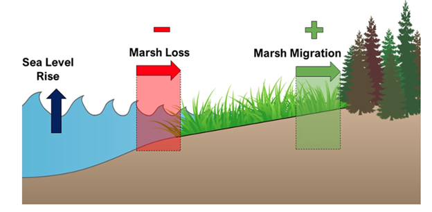
Coastal tidal marshes can “migrate” into adjacent uplands, through accretion of sediment which increases surface elevation and allows marshland to develop above continuously rising waters. If water level rises too quickly, current marshlands will become open water and too wet for marsh plants to survive (Fagherazzi et al., 2019). If the area inland of the marsh is unimpeded by man-made barriers, such as seawalls, and is high enough to bring the marsh close to or slightly above sea level, then with the right conditions, marsh flora may be able to shift inland. As storms inundate upland areas, upland soils will become saltier, causing die back of upland plants and creating conditions for marsh plants to grow (Fagherazzi et al., 2019). This form of “migration” can keep coastal tidal marshes from being lost altogether or can possibly even expand marshland area in some places. However, as marshes move inland, other ecosystems or land uses will be lost or transformed. This may mean a loss of arable agricultural land or forested areas which is already happening in the Carolinas (Martinez and Ardón, 2021, Holman 2022, Breisinger 2021, NOAA). Farmers in some low-lying areas have had increasing issues with saltwater intrusion from storm surges (Kaplan, 2019, CISA University of South Carolina, 2012). Forested freshwater swamps along tidal creeks and rivers have transitioned to tidal marshes full of dead or dying trees, named “ghost forests” due to their gray skeleton-like appearance (Martinez and Ardón, 2021; Holman, 2022; Breisinger, 2021).
Wetlands can store precipitation and slowly release it over time, which reduces stormwater runoff and lessens flash flood damage both locally and downstream. Furthermore, wetlands reduce the number of severe overbank flooding events by holding and storing significant amounts of floodwater from overflowing streams.[19] The U.S. Environmental Protection Agency (EPA) estimates that one acre of wetland can store up to 1.5 million gallons of water.[19] Studies have shown that small, isolated wetlands have higher rates of evapotranspiration (evaporation of water and plants soaking up water and releasing it into the atmosphere) than larger bodies of water, indicating that smaller wetlands can reduce stormwater runoff more efficiently than larger ones.[20] The water absorbed in the wetland soils helps replenish water levels in streams and reduces drought on land during dry periods. As temperatures rise over the next century, “[i]t is likely that future severe droughts…will be more frequent and intense.”[18] Having wetlands dispersed throughout a watershed (an area where all water drains across the landscape to one common point) is crucial to minimize drought impacts. In coastal areas, small wetlands can reduce saltwater intrusion through groundwater recharge which helps protect freshwater wetlands from negative impacts such as tree mortality that may result from increased salinity levels by maintaining the water table levels at about sea level.[20] Protecting coastal freshwater wetlands reduces flood damages from storm surge.
Water Quality Benefits
A common misconception is that small wetlands are isolated and therefore do not provide important hydrological and water quality benefits. All wetlands, small and large, are part of the larger surrounding watershed and can influence other ecosystems within the watershed. Evapotranspiration is an important ecosystem service provided by small wetlands that stabilizes the health of the surrounding watershed by reducing excess stormwater runoff that can carry harmful contaminants, excess nutrients, and sediment that impair water quality (Figure 3). For example, when analyzing the same rainfall event, “one inch of rain on an acre of woods produces little to no stormwater runoff” while “one inch of rain on an acre of asphalt produces 27,000 gallons of stormwater runoff that contains a variety of pollutants and causes widespread erosion.”[22] Small wetland vegetation and microtopography on the soil surface improve water quality by slowing the movement of water downslope and allowing for sediment to settle out, bacteria to breakdown contaminants, and excess nutrients to be taken up by plants and microorganisms, thus improving water quality. The wetland’s “natural filtration process makes water cleaner for drinking, swimming, and provides habitat for plants and animals.”[19]
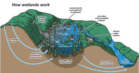
Figure 3. How wetlands work and their role in water quality and ecosystem health (23).
Recreational Benefits
In 2016, 103.7 million Americans spent $156.9 billion participating in recreational activities such as hunting; fishing; and observing, feeding, and photographing wildlife in natural areas (Figure 4).[24] The 2011 National Survey of Fishing, Hunting, and Wildlife-Associated Recreation report for North Carolina showed a total of $3.3 billion was spent on recreational activities related to wildlife that included $525 million for hunting, $1.5 billion spent for fishing, and $930 million spent for wildlife-watching.[25] People visiting small wetlands to hunt, fish, and observe wildlife can boost local economies, especially in rural areas, by spending money on and requiring services for transportation, lodging, food, beverages, equipment, licenses, permits, memberships, and/or land leases.
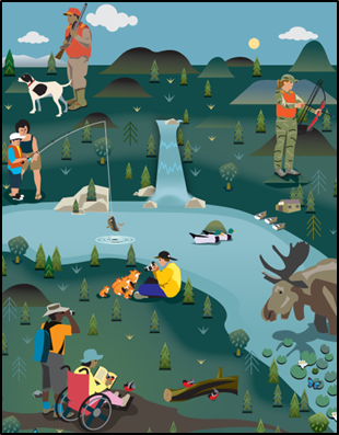
Figure 4. Wildlife-dependent recreational activities (26).
In a public input survey conducted in 2014 by the North Carolina Division of Parks and Recreation (DPR), most respondents (81%) believe it is “extremely or somewhat important to spend public funds to acquire land and develop outdoor state parks and recreation areas in North Carolina” but many indicated that a lack of time (59%) or a lack of available facilities (23%) are barriers to their participation in outdoor recreation.[27] Preserving small wetlands and adding amenities such as walking trails in urban and residential areas makes outdoor recreation activities more accessible. This would also improve nearby property values and promote healthier lifestyles, including physical and mental health.[28] The economic benefit gained from recreational activities heavily depends on the presence and health of local wetlands.
Biodiversity Benefits
Wetlands host a variety of plant and animal species, including approximately 70% of rare or endangered species in North Carolina that require wetlands to survive.[29] In the Mountains and western Piedmont, small wetlands provide habitat for over 90 rare, threatened, or endangered plant and animal species.[30] Mountain bogs are typically small and are among the rarest, most vulnerable habitats in the United States. These wetlands are the only or primary habitat for wildlife species such as the southern bog lemming (Synaptomys cooperi), a type of small mammal, the bog turtle (Glyptemys muhlenbergii), and plants species including swamp pink (Helonias bullata), mountain sweet pitcher plant (Sarracenia rubra), and bunched arrowhead (Sagittaria fasciculata).[30,12] Without mountain bogs, these species, along with many others, would not be able to survive. These species are adapted to wetlands without the high velocities of water that stream floodplain wetlands experience.
On January 13, 2022, the Center for Biological Diversity filed a petition to the U.S. Fish and Wildlife Service (USFWS) “to protect the southern population of the bog turtle as a federal endangered species in Virginia, North Carolina, Tennessee, and Georgia” and request the establishment of designated critical habitat.[32] There are currently only 10 sites with viable bog turtle populations (at least 40 individuals) in North Carolina.[32] Almost all the individuals found at these sites were adults, meaning there are very few young turtles to replace the adults and continue the survival of the species.[32] By listing the bog turtle as a federal endangered species and designating critical habitat, protection would be provided under the Endangered Species Act for mountain bogs that are used by existing populations.
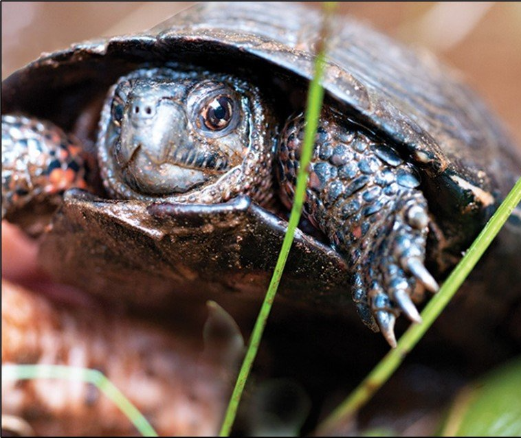
Photo: The Appalachian Voice. 2014 (31).
Solutions
Some Carolina coastal tidal marshes are not able to naturally migrate due to man-made barriers or an inability to accrete sediment faster than rising sea levels. In other states natural barriers such as rocky outcrops and steep slopes may also impede marsh migration (Fuller et. al., 2011). Human intervention may aid migration through the creation of marsh migration corridors. Corridors consist of upland areas onto which marshes can slowly move upward as sea levels rise. These corridors require sufficient elevation for marshes to be higher than open water, a lack of physical barriers to migration, and a suitable natural landscape for marsh habitat to establish and thrive.
Humans can aid in the development of marsh migration corridors using the Resist-Accept-Direct (RAD) methodology (Shuurman et al., 2020). With this method, we can resist negative changes to our coastal system by avoiding the worst impacts of sea level rise, accept the inevitable inundation of some of our marshes, and direct the marshes’ inland migration by facilitating open corridors and conditions in which new marshland will thrive.
There are several projects along the Atlantic coast creating strategies for the creation of marsh migration corridors aimed at maintaining or increasing the total area of marshland in each area, especially as sea level rises. The scope of these projects varies from preservation of predicted natural migration corridors, to prioritization of locations for intentional marsh migration corridors, to implementation of public and private means of anthropogenically facilitating marsh migration in certain areas. The strategies suggested by these projects or related studies of marsh migration include physical alterations to the landscape, regulatory restrictions or incentive programs, and public/community outreach and involvement. Some of these strategies are highlighted below:
Identify Potential Corridors
One of the major areas of focus in marsh migration corridor research has been the identification and prioritization of potential corridors. Digital methods have included the use of Geographic Information Systems (GIS) and modeling techniques to remotely determine which areas are most suitable for corridors (EPA, 2016). Assessments using these techniques may look for available land parcels adjacent to current marshes. They may also use elevation data and estimates of sea level rise to detect the most vulnerable areas of marshland in need of corridors. Other models will assess potential marsh habitat as a way of prioritizing marsh corridor locations. Many governmental and academic groups are using such models as the National Oceanic and Atmospheric Administration (NOAA) Habitat Priority Planner (NOAA Coastal Services Center, n.d.), the Salt Marsh Coastal Parcel Planning Tool (Road Island Salt Marsh Conservation Project n.d.), and the Sea Level Affecting Marshes Model (SLAMM) (Warren Pinnacle Consulting Inc., 2017). Additionally, the value of potential corridors to surrounding communities can play a big role in prioritizing corridors. If a current land use is more valuable to a community than a coastal tidal marsh, there may be resistance to a marsh migration corridor (Fagherazzi et al., 2019).
Coordinate with Local Communities and Stakeholders
Many studies have highlighted the great need to work with coastal communities and local organizations to make marsh migration a success. Local communities have their own needs and desires when it comes to marsh management. It is critical to involve the local community in shaping their own landscapes. Aligning environmental goals with community goals can help ensure the longevity of projects and avoid environmental injustices. Local communities and stakeholders have knowledge and resources that can contribute to mutually beneficial projects. They can also be important stewards of marsh migration corridors. Corridors can be created in ways that help uplift surrounding communities and fit in with their goals and needs. They can provide important ecosystem services to communities if community collaboration is obtained. Collaborating with communities in every step of the process is essential to successful projects (Van Dolah et al., 2020). A unique example of local collaboration in the coastal Carolinas is with the Gullah-Geechee community. This community is deeply knowledgeable about their local marshes and the threats that face them. They are currently part of a PEW Charitable Trust initiative to conserve a million acres of marsh. These lands are sacred to this community and thus working with the Gullah-Geechee is especially important (PEW, 2021a).
Transition Agriculture
Many coastal marshes in the Carolinas are bordered inland by agricultural fields. As sea levels rise, agricultural fields are becoming inundated with salt water, limiting the land available for farmers to grow the crops that they grew previously (Fagherazzi et al., 2019). However, there are opportunities for farmers to both protect their future finances and create space for inland marsh migration. Alternative future scenarios for farmers include, continuing current farming activities while maintaining a buffer of tidal marshland between agricultural land and open water or the planting of salt tolerant marsh crops (Lerner et al., 2013). These marshes can protect crops further inland by absorbing flooding events and preventing salt-water intrusion of cropland, allowing farmers to continue to farm some of their land as sea level rises. Another option is for farmers to transition from growing crops to aquaculture that is compatible with marshes (Andrews, 2020). With this option, the land could still be used for economic benefit, while simultaneously allowing for marsh migration. Working with farmers will be an essential component of any large-scale creation of marsh migration corridors in the Carolinas.
Conservation and Land Management
An essential component to creating migration corridors will be putting land into conservation easements and appropriately managing those easements to promote marsh migration (Fagherazzi et al., 2019). Funding for the purchase of easements could come from The Federal Land and Water Conservation Fund, the Wetlands Reserve Program, and local land trusts, among others (Lerner et al., 2013). Some of the best practices for managing the areas upland of current marshes is to remove dead trees, invasive species, and man-made barriers that may impede migration (Beever et al., 2012; Lerner et al., 2013; University of Rhode Island, n.d.; Andrews, 2020). Dead trees left standing in transitioning forest lands inland of these marshes may limit salt marsh bird nesting habitat (Lerner et al., 2013) and even contribute to greenhouse gas emissions, by assisting the release of methane from soils (Martinez and Ardón, 2021). Hydrology and topography must also be managed so that water flows bring a steady supply of sediment to marshes (Beever et al., 2012: University of Rhode Island, n.d.). This is especially important for salt marshes that may become sediment starved (Moorman, 2021). Other management strategies have included increasing surface area elevation and reducing interior ponding (Lerner et al., 2013) and back-filling man-made pits and ditches (Beever et al., 2012).
Regulatory Action
Many communities are turning to regulatory action to protect the future of their coastal wetlands. Regulatory actions or governmental incentives have been used all along the Atlantic coastline to curb coastal development practices. Some innovative policies have included laws and regulations making living shorelines standard practice in coastal Virginia (Andrews, 2020). Living shorelines are protected and stabilized shorelines made from natural materials such as plants, sand, and rocks. The use un-hardened living shorelines, devoid of rip rap (Beever et al., 2012), can help create a transition zone for landward moving marshes. There have also been several communities in which the new development of hardened coastal surfaces more generally has been limited (Van Dolah et al., 2020; Andrews, 2020).
There are also communities in which developers are given incentives to place ideal migration corridor land in easements, in order to be rewarded with permits issued for denser development in other locations (Andrews, 2020). In areas where flooding affects homes, there are state and federal programs that can be used to voluntarily buy back land from homeowners and create easements from those tracts of land. As sea levels rise and coastal flooding worsens, these programs may be an avenue for converting developed land into corridors. However, it should be noted that the uprooting of communities in this way and the inequities associated with many communities that are adversely affected by flooding brings with it issues of environmental justice that must simultaneously be considered and addressed.
Carbon Markets
Another creative idea is the use of carbon markets and nutrient reduction incentives to encourage the protection of coastal marshes and private contributions to marsh migration corridors in order to meet project requirements or obtain pollution credits (RI Salt Marsh Conservation Project, n.d.).
Specific strategies especially for working with farmers and the communities along with details behind these strategies can be found in the resources in the Reference section.
Conclusions
Protecting the coastal marshes of the Carolinas will be a major challenge in the coming decades, but with forethought, planning, and the cooperation of diverse stakeholders across the region there is a positive outlook for the future of these wetlands. We have the tools and knowledge necessary to successfully create marsh migration corridors through which marshes can move inland. With adequate funding, resources, and local community involvement these corridors can become a reality. The PEW Charitable Trust and the Southeast Regional Partnership for Planning and Sustainability are already working on such large-scale projects (PEW, 2021b). Successful projects in the Chesapeake Bay Region (Lerner et al., 2013) can serve as models going forward. As sea levels rise, managed marsh migration corridors will be critical for the protection of this valuable Carolina wetland resource.
Meet the Author
Chase Bergeson is an environmental scientist living in Raleigh, NC. She is passionate about working with communities on conservation of our water resources. She has an MS in Natural resources from NC State University and has experience working in water quality monitoring, environmental consulting, and environmental education. She loves to spend time with her friends and family, travel, swim, kayak, and walk in the woods
References
Andrews, E.A. Legal and Policy Challenges for Future Marsh Preservation in the Chesapeake Bay Region. Wetlands 40, 1777–1788 (2020). https://doi.org/10.1007/s13157-020-01389-z
Beever, L. B., Gray, W., Cobb, D., & Walker, T. (2012). Climate Change Vulnerability Assessment and Adaptation Opportunities for Salt Marsh Types in Southwest Florida. The Charlotte Harbor National Estuary Program.
Breisinger, H. (2021). North Carolina’s shoreline estuaries are transforming into “ghost forests,” by why? WHQR Public Media. https://www.whqr.org/local/2021-06-03/north-carolinas-shoreline-estuaries-are-transforming-into-ghost-forests-but-why
Carolina Integrated Sciences and Assessments, University of South Carolina. 2012. Assessing the Impact of Saltwater Intrusion in the Carolinas under Future Climatic and Sea Level Conditions. https://cpo.noaa.gov/sites/cpo/Projects/RISA/2013/reports/2012_CISAandSCSeaGrant_SalinitySARPReport.pdf
EPA. (2016, April 14). Maryland Analyzes Coastal Wetlands Susceptibility to Climate Change (District of Columbia) [Overviews and Factsheets]. https://www.epa.gov/arc-x/maryland-analyzes-coastal-wetlands-susceptibility-climate-change
Fagherazzi, Sergio, et al. “Sea Level Rise and the Dynamics of the Marsh-Upland Boundary.” Frontiers Environmental Science, vol. 7, 2019, https://www.frontiersin.org/article/10.3389/fenvs.2019.00025.
Fuller, Roger, et al. Marshes on the Move. The Nature Conservancy Global Marine Team and NOAA National Ocean Service Coastal Services Center, Oct. 2011.
Guimond, J. A., & Michael, H. A. (2021). Effects of marsh migration on flooding, saltwater intrusion, and crop yield in coastal agricultural land subject to storm surge inundation. Water Resources Research, 57, e2020WR028326. https://doi.org/10.1029/2020WR028326
Habitat Priority Planner: Marsh Migration. (n.d.). NOAA Coastal Services Center. Retrieved November 3, 2021, from https://coast.noaa.gov/data/digitalcoast/pdf/hpp-applications-marsh-migration.pdf
Holman, V. 2022. Ghost Whisperers. Salt Magazine. http://www.saltmagazinenc.com/ghost-whisperers/.
Kaplan, S. (2019, March 1). Ruined crops, salty soil: How rising seas are poisoning North Carolina’s farmland. The Washington Post. https://www.washingtonpost.com/national/ruined-crops-salty-soil-how-rising-seas-are-poisoning-north-carolinas-farmland/2019/03/01/2e26b83e-28ce-11e9-8eef-0d74f4bf0295_story.html
Kozak, C. (2019, December 10). Currituck Marsh Focus for Resilience Project. CoastalReview.org. https://coastalreview.org/2019/12/currituck-marsh-focus-for-resilience-project/
Kottler, Ezra. “Sea-Level Rise, Marsh Migration, and Coastal Resilience.” Wetland Restorations, 22 Mar. 2021, https://wmap.blogs.delaware.gov/2021/03/22/sea-level-rise-marsh-migration-and-coastal-resilience/.
Ladin and Moorman, 2021, USFWS, Southeast Region SET Analysis, https://ecos.fws.gov/ServCat/DownloadFile/199786
Lerner, J.A., Curson, D.R., Whitbeck, M. and Meyers, E.J., Blackwater. 2100: A strategy for salt marsh persistence in an era of climate change, 2013, The Conservation Fund (Arlington, VA) and Audubon MD-DC (Baltimore, MD).
Martinez, M., Ardón, M. Drivers of greenhouse gas emissions from standing dead trees in ghost forests. Biogeochemistry 154, 471–488 (2021). https://doi.org/10.1007/s10533-021-00797-5
Moorman, M. (2021, September 26). Will the Marsh Stay or Will It Go? Coastal Wetland Transformations in the South Atlantic Basin.
Nagy, R. (2015). Moving Through the Marsh. Coastwatch, Winter 2015. https://ncseagrant.ncsu.edu/coastwatch/previous-issues/2015-2/winter-2015/moving-through-the-marsh/
National Geographic. (n.d.). Marsh. National Geographic Resource Library. Retrieved November 3, 2021, from https://www.nationalgeographic.org/encyclopedia/marsh/
NC Interagency Leadership Team. 2010. Climate maps. Maps produced by Renci (Renaissance Computing Institute) and UNC Asheville’s NEMAC (National Environmental Modeling and Analysis Center) http://www.climatechange.nc.gov/Climate_Maps_NC.pdf
PEW. (2021a). African Descendants Have Stake in Saving U.S. Southeast Salt Marshes. https://pew.org/3hvVEjm
PEW. (2021b). How Southeast Stakeholders Are Safeguarding Salt Marshes. https://pew.org/3qZyQLH
RI Salt Marsh Conservation Project. (n.d.). The University of Rhode Island Environmental Data Center. Retrieved November 3, 2021, from https://www.edc.uri.edu/ri-salt-marsh-conservation-project/
Schuurman, G., Cat, H.-H., Cole, D., Lawrence, D., Morton, J., Magness, D., Cravens, A., Covington, S., O’Malley, R., & Fisichelli, N. (2020). Resist-Accept-Direct (RAD)—A Framework for the 21st-century Natural Resource Manager. National Park Service. https://doi.org/10.36967/nrr-2283597
Van Dolah, E.R., Miller Hesed, C.D. & Paolisso, M.J. Marsh Migration, Climate Change, and Coastal Resilience: Human Dimensions Considerations for a Fair Path Forward. Wetlands 40, 1751–1764 (2020). https://doi.org/10.1007/s13157-020-01388-0
Warren Pinnacle Consulting, Inc. (2017). SLAMM: Sea Level Affecting Marshes Model. http://warrenpinnacle.com/prof/SLAMM/index.html
Small wetland habitats across North Carolina are also critical breeding grounds for amphibian and crayfish species because they often do not contain fish predators that may be present in larger, more permanently flooded water bodies.[33] In North Carolina, small wetlands are habitat to approximately 20 species of salamanders, including two state-listed threatened species [Eastern tiger salamander (Ambystoma tigrinum tigrinum) and Mabee’s salamander (Ambystoma mabeei)] and three state-listed species of special concern [dwarf salamander (Eurycea quadridigitata), four-toed salamander (Hemidactylium scutatum), and mole salamander (Ambystoma talpoideum)].[33, 34, 35, 36] There are also many species of frogs and toads in North Carolina that use small wetlands as habitat and breeding grounds, including two state-listed endangered species [Carolina gopher frog (Rana capito) and ornate chorus frog (Pseudacris ornata)], one state-listed threatened species [pine barrens treefrog (Hyla andersonii)], and one state-listed species of special concern [northern gray treefrog (Hyla versicolor)]. [33, 34, 35, 36]
Small wetlands tend to attract wading birds, waterfowl, and songbirds since they are prime nesting and feeding areas.[33] Many migratory birds such as egrets, falcons, hawks, herons, waterfowl, and vultures depend on wetlands during their migration and breeding seasons.[37] Small wetlands host a variety of invertebrates and insects that are an excellent food source for birds and other wildlife.[20] All animals require drinking water for survival; therefore, small wetlands are an important clean water drinking source for wildlife, especially in areas surrounded by uplands where drinking sources may be limited. Many mammals including bats, black bears, bobcats, coyotes, opossums, rabbits, raccoons, skunks, and white-tailed deer utilize both wetland and upland habitats.
The loss and degradation of small wetlands have negative consequences for biodiversity and can lead to the extinction of endangered species. Development can cause a direct loss of wetlands due to filling and draining, but other impacts such as increases in impervious surfaces, accelerated drainage, habitat fragmentation, pollution, decrease in water quality, and the introduction of exotic invasive species all threaten the health and existence of small wetland habitats.
SOLUTION: Protect Small Wetlands
As federal regulations surrounding wetland protection continue to change, it is important that state rules incorporate measures to strengthen regulations to protect small wetlands. During the Trump administration, many wetlands lost federal protection under the Navigable Wetlands Protect Rule (NWPR) that went into effect in June 2020, including small wetlands that were not considered “adjacent wetlands” to jurisdictional waters required by the NWPR. It was estimated approximately 1.3 million acres of wetlands in North Carolina lost federal protection under the NWPR.[38] To meet the federal non-jurisdictional wetland permitting gap that the NWPR created for wetlands that were not isolated but no longer met the federal definition of a jurisdictional wetlands, North Carolina passed temporary rules; however, these temporary rules had high permitting thresholds (one acre in the Coastal Plain, one-half acre in the Piedmont, and one-third acre in the Mountains), so many small wetland losses were considered “deemed permitted” and these wetlands were not protected and losses were not reported.[39] North Carolina then started working on permanent rules and proposed lowering the permitting threshold for all non-isolated wetlands to one-tenth acre, including those considered federally non-jurisdictional.40 In August 2021, the U.S. District Court for the District of Arizona issued an order vacating and remanding the NWPR resulting in the Waters of the US (WOTUS) pre-2015 rule being reinstated.[41] To address any possible future changes to the federal protection of wetlands, North Carolina is still continuing to pursue the permanent rules that would better protect small wetlands statewide. This will encourage projects to include more rigorous avoidance and minimization measures to reduce costs associated with permitting and mitigation for impacts to wetlands.
While this would be a positive step forward for wetland protection, it should be noted that more than half of wetlands in the Mountains and about half of wetlands in the Piedmont were found to be less than one-tenth acre in recent studies conducted by the DWR (Figure 2), which means some of these wetlands can be lost without permitting requirements if total impacts for a project are less than one-tenth acre.[5] Permitting thresholds for impacts to isolated wetlands, such as mountain bogs and basin wetlands, are higher than one-tenth acre: one acre in the Coastal Plain, one-half acre in the Piedmont, and one-third of an acre in the Mountains.[42] While isolated wetlands do not have a direct surface connection to relatively permanent waters, they still perform functions that are important for the overall health of a watershed, wildlife, and humans. Because the size of a wetland is not a direct indicator of how well it is functioning or the value it has to the surrounding ecosystem, other criteria such as wetland density, position, and ecological value within a watershed, need to be incorporated into wetland regulations.1 A landscape approach to regulate wetlands can be used to avoid and minimize impacts to wetlands that are in positions that provide the most environmental, economic, and community benefits. An updated, accurate map of wetlands in North Carolina would provide a greater level of understanding for where small wetlands occur, better inform wetland regulations, and potentially streamline the environmental permitting process. [5]
Conclusions
Small wetlands offer considerable benefits to North Carolina through environmental and economic services. Small wetlands provide flood protection against growing impacts from climate change including stronger storms and increasing heavy downpour events and have been shown to be more efficient at reducing runoff than larger wetlands and are a main source of water and sediment filtration that improves water quality. Small wetlands provide habitat for rare, threatened, and endangered species; therefore, their protection is imperative in the face of growing extinction events. Small wetlands serve as critical breeding grounds for amphibian species and are necessary feeding and drinking sources for wildlife. They support recreational opportunities and stimulate the economy.
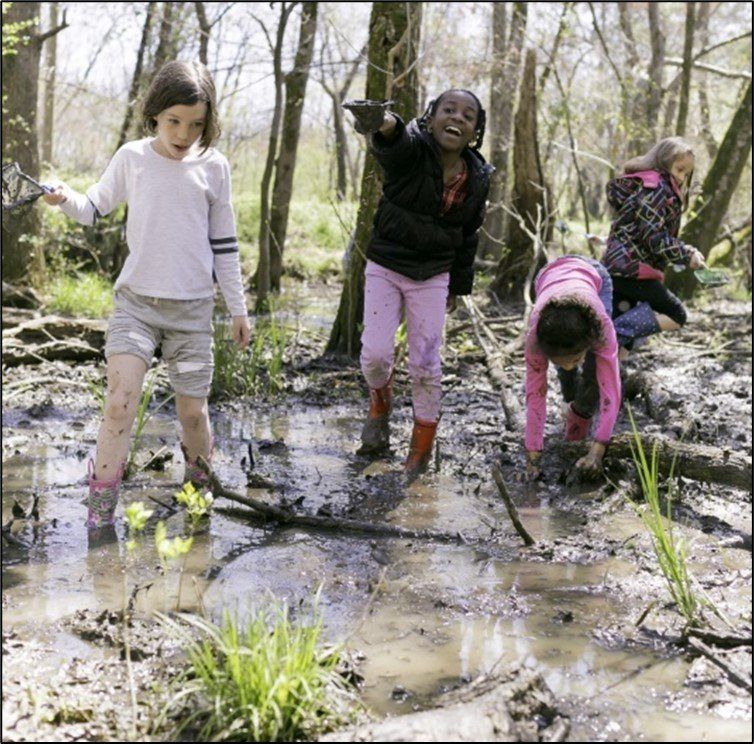
Photo: Walter Magazine. 2019. Exploring the Walnut Creek Wetland Center. Photography by Justin Kase Conder (41).
The importance of small wetlands warrants their protection. Because federal wetland regulations fluctuate over time and use size as the primary requirement for permitting, the state of North Carolina should develop and maintain regulations that give protection to small wetlands based on their abundance and position in the watershed, beneficial services, and ecological importance.

About the Author
Amanda Johnson is a Professional Wetland Scientist who works as an environmental scientist. She has been a volunteer with Carolina Wetlands Association since 2019 where she serves as the Project Manager for the North Carolina Pilot Volunteer Wetlands Monitoring Program and is a member of the Science Committee. In her free time, she enjoys spending time with her family, dog, and cat.
References
- Snodgrass, Joel W., et al. (2001). Relationships among Isolated Wetland Size, Hydroperiod, and Amphibian Species Richness: Implications for Wetland Regulations. Conservation Biology, vol. 14, no. 2, 24, pp. 414–419. https://conbio.onlinelibrary.wiley.com/doi/abs/10.1046/j.1523-1739.2000.99161.x. (Accessed July 16, 2021).
- Natural Resource Conservation Service (NCRS), United States Department of Agriculture (USDA). (n/d). Wetlands. https://www.nrcs.usda.gov/wps/portal/nrcs/main/national /water/wetlands/. (Accessed February 1, 2022).
- NRCS, USDA. (1995). Wetland Values and Trends. RA Issue Brief #4. nrcs.usda.gov/wps/portal/nrcs/detail/nc/home/?cid=stelprdb1042133. (Accessed February 1, 2022).
- Richardson, C.J. (2003). Pocosins: Hydrologically isolated or integrated wetlands on the landscape?. Wetlands 23, 563–576. https://doi.org/10.1672/0277-5212(2003)023[0563:PHIOIW]2.0.CO;2. (Accessed February 1, 2022).
- Gale, S. (2021). National Wetlands Inventory (NWI) Accuracy in North Carolina. Division of Water Resources (DWR), North Carolina Department of Environmental Quality (NCDEQ). https://www.ncwetlands.org/wp-content/uploads/NWI_Accuracy_In_NC_NCDWR-Final_Report_8-10-2021.pdf. (Accessed February 1, 2022).
- The Nature Conservancy. (n/d). Stories in North Carolina: Southern Appalachian Mountain Bogs. https://www.nature.org/en-us/about-us/where-we-work/united-states/north-carolina/stories-in-north-carolina/mountain-bogs/. (Accessed February 1, 2022).
- Sharitz, R.R. (2003). Carolina bay wetlands: Unique habitats of the southeastern United States. Wetlands 23, 550–562. https://link.springer.com/article/10.1672/0277-5212(2003)023%5b0550:CBWUHO%5d2.0.CO;2. (Accessed February 1, 2022).
- United States Environmental Protection Agency (EPA). (n/d). What is a Wetland? https://www.epa.gov/wetlands/what-wetland. (Accessed February 1, 2022).
- (2011). North Carolina Level III Shapefile. https://www.epa.gov/eco-research/ecoregion-download-files-state-region-4. (Accessed December 19, 2021).
- North Carolina Wildlife Resources Commission (NCWRC). (2016). 2015 Wildlife Action Plan. https://www.ncwildlife.org/Portals/0/Conserving/documents/2015WildlifeActionPlan/NC-WAP-2015-All-Documents.pdf. (Accessed February 1, 2022).
- United States Fish and Wildlife Service (USFWS). (2019). National Wetlands Inventory North Carolina Shapefile. https://www.fws.gov/node/264847. (Accessed October 8, 2021).
- DWR, NCDEQ. (2021a). North Carolina Wetlands Information. Water Sciences Section. https://www.ncwetlands.org. (Accessed February 1, 2022).
- DWR, NCDEQ. (2021b). North Carolina Wetlands Information. Water Sciences Section. Accuracy of National Wetland Inventory (NWI) Maps in North Carolina. https://www.ncwetlands.org/project/nwi_accuracy/
- NC Wetland Functional Assessment Team. 2016. NC Wetland Assessment Method (NC WAM) User Manual Version 5. https://files.nc.gov/ncdeq/Water%20Quality/Environmental%20Sciences/ECO/Wetlands/NC%20WAM%20User%20Manual%20v5.pdf. (Accessed February 1, 2022).
- Carolina Wetlands Association. (2020). Wetlands and Climate Change. http://carolinawetlands.org/wp-content/uploads/2021/04/WetlandsClimateChange_WhitePaper-Final-Dec2020.pdf. (Accessed February 1, 2022).
- Gallup, J. (2021). Quickbait: Hurricane Season. INDY WEEK. https://indyweek.com/news/northcarolina/quickbait-hurricane-season/. (Accessed December 30, 2021).
- Inflation Tool. (2021). Inflation calculator – US Dollar. https://www.inflationtool.com/us-dollar?amount=500000&year1=1970&year2=2021&frequency=yearly. (Accessed February 1, 2022).
- Kunkel, K.E., D.R. Easterling, A. Ballinger, S. Bililign, S.M. Champion, D.R. Corbett, K.D. Dello, J. P. Dissen, G.M. Lackmann, R.A. Luettich, Jr., L.B. Perry, W.A. Robinson, L.E. Stevens, B.C. Stewart, and A.J. Terando. (2020). North Carolina Climate Science Report. North Carolina Institute for Climate Studies. https://ncics.org/nccsr. (Accessed January 17, 2022).
- (2006). Economic Benefits of Wetlands. Office of Water. https://www.epa.gov/sites/default/files/2016-02/documents/economicbenefits.pdf. (December 30, 2021).
- Braun, D. G., and V. C. Clark. (2017). The Benefits of Small Wetlands. https://theguardiansofmartincounty.com/wp-content/uploads/2017/04/BenefitsofSmallWetlands.pdf. (Accessed February 1, 2022).
- Ushe, Naledi. (2021). 2 Dead, at Least 35 Missing as Homes ‘Are Completely Destroyed’ in North Carolina. https://people.com/human-interest/2-dead-at-least-35-missing-and-homes-are-completely-destroyed-in-north-carolina-floods/. (Accessed January 17, 2022).
- City of Charlotte. (n/d). Stormwater & Pollution of Streams and Lakes. Charlotte-Mecklenburg Storm Water Services. https://charlottenc.gov/StormWater/SurfaceWaterQuality/Pages/StormwaterandPollutionofStreamsandLakes.aspx. (Accessed January 17, 2022).
- Kanabec SWCD. (n/d). Wetlands. http://www.kanabecswcd.org/wetlands/. (December 30, 2021).
- (2016). Quick Facts from the 2016 National Survey of Fishing, Hunting and Wildlife-Associated Recreation. https://www.census.gov/content/dam/Census/library/visualizations/2016/demo/fhw16-qkfact.pdf. (Accessed December 30, 2021).
- (2013). Survey Identifies Value of Hunting and Fishing to N.C. Economy. https://www.ncwildlife.org/News/survey-identifies-value-of-hunting-and-fishing-to-nc-economy. (Accessed on December 30, 2021).
- (2016). 2016 National Survey of Fishing, Hunting and Wildlife-Associated Recreation. https://www.census.gov/content/dam/Census/library/visualizations/2016/demo/fhw16-qkfact.pdf. (Accessed December 30, 2021).
- Division of Parks and Recreation, North Carolina Department of Natural and Cultural Resources. (2020). North Carolina Outdoor Recreation Plan 2020-2025. https://files.nc.gov/ncparks/north-carolina-statewide-comprehensive-outdoor-recreation-plan-2020.pdf. (Accessed December 30, 2021).
- Miracle Recreation. (n/d). Benefits of Parks in Your Community. https://www.miracle-recreation.com/blog/benefits-of-parks-in-your-community/. (Accessed December 30, 2021).
- Bales, Jerad D, and Douglas J Newcomb. (1996.) North Carolina Wetland Resources. National Water Summary on Wetland Resources. https://www.fws.gov/wetlands/data/Water-Summary-Reports/National-Water-Summary-Wetland-Resources-North-Carolina.pdf. (Accessed February 1, 2022).
- (n/d). Mountain Bogs. https://www.fws.gov/southeast/pubs/mtbog.pdf. (Accessed December 30, 2021).
- Ellis, Amber. (2014). Exploring Mountain Bogs. The Appalachian Voice. https://appvoices.org/2014/08/10/exploring-mountain-bogs/. (Accessed April 12, 2022).
- Center for Biological Diversity. (2022). Petition to List the Southern Population of the Bog Turtle (Glyptemys muhlenbergii) Under the Endangered Species Act as an Endangered or Threatened Species and to Concurrently Designate Critical Habitat. https://s3-us-west-2.amazonaws.com/s3-wagtail.biolgicaldiversity.org/documents/Bog-Turtle-Southern-Population-Petition.pdf. (January 31, 2022).
- (2004). Piedmont Small Wetland Communities, Piedmont Ecoregion. https://www.wrcuatweb.org/Portals/0/Conserving/documents/Piedmont/P_Small_wetland_communities.pdf?ver=A2CJzJbrPhmWtjX-0W009Q%3d%3d. (Accessed February 1, 2022).
- (2004). Small Wetland Communities, Mid-Atlantic Coastal Plain. https://www.ncwildlife.org/Portals/0/Conserving/documents/Coast/CP_Small_wetland_communities.pdf?ver=rhHkfWCDWhPlB1iPmQganw%3d%3d. (Accessed February 1, 2022).
- National Park Service. (n/d). Blue Ridge Amphibian and Reptile Checklist. https://www.nps.gov/blri/learn/nature/upload/BLRI-Herps-Checklist-cb-edits.pdf. (Accessed April 11, 2022).
- (2021). Protected Wildlife Species of North Carolina. https://www.ncwildlife.org/Portals/0/Conserving/documents/Protected-Wildlife-Species-of-NC.pdf. (Accessed April 11, 2022).
- Stewart, Robert E. Jr. (2016). Technical Aspects of Wetlands, Wetlands as Bird Habitat. National Water Summary on Wetland Resources. https://water.usgs.gov/nwsum/WSP2425/birdhabitat.html. (Accessed April 11, 2022).
- DWR, NCDEQ. (2021). Regulatory Impact Analysis: Reinstating Permitting Mechanism for Non-Jurisdictional Wetlands and Waters. https://edocs.deq.nc.gov/WaterResources/DocView.aspx?id=2051205&dbid=0&repo=WaterResources. (Accessed January 31, 2022).
- Discharges to Federally Non-Jurisdictional Wetlands and Federally Non-Jurisdictional Classified Surface Waters. 15A NCAC 02H. 1401-.1405 and .1301. Temporary Rules. (2021). https://edocs.deq.nc.gov/WaterResources/DocView.aspx?id=1898665&dbid=0&repo=WaterResources&cr=1. (Accessed January 31, 2022).
- Discharges to Federally Non-Jurisdictional Wetlands and Federally Non-Jurisdictional Classified Surface Waters. 15A NCAC 02H. 1401-.1405 and .1301. Proposed Permanent Rules. (2021). https://edocs.deq.nc.gov/WaterResources/DocView.aspx?id=2051206& dbid=0&repo=WaterResources. (Accessed January 31, 2022).
- The National Law Review. (2021). Uncertainty Over ‘Waters of the U.S.’ Definition Continues, as Federal Court in Arizona Vacates 2020 Rule. https://www.natlawreview.com/article/uncertainty-over-waters-us-definition-continues-federal-court-arizona-vacates-2020. (Accessed April 11, 2022).
- Isolated Wetlands and Waters (non-404) Rules. 15A NCAC 02H.1305. (2021). https://edocs.deq.nc.gov/WaterResources/DocView.aspx?id=2051206& dbid=0&repo=WaterResources. (Accessed January 31, 2022).
- Walter Magazine. (2019). Exploring the Walnut Creek Wetland Center. https://waltermagazine.wpengine.com/explore/slideshow-walnut-creek-wetland-center/. (Accessed December 30, 2021).
Mailing Address
Carolina Wetlands Association
PO Box 3359
Raleigh, NC 27636
Mailing Address
Carolina Wetlands Association
PO Box 3359
Raleigh, NC 27636
Mailing Address
Carolina Wetlands Association
PO Box 3359
2Raleigh, NC 27636
All Rights Reserved | Carolina Wetlands Association